
Land Cover Map 2000
(LCM2000)
 The Land Cover Map 2000 (LCM2000) is a series of data products produced by the Centre for Ecology & Hydrology, based on a parcel-based thematic classification of satellite image data covering the entire United Kingdom. LCM2000 is derived from a computer classification of satellite scenes obtained mainly from the Landsat sensor. It incorporates information derived from other ancillary datasets. LCM2000 was classified using a hierarchical nomenclature corresponding to the Joint Nature Conservation Committee (JNCC) Broad Habitats, which encompasses the entire range of UK habitats. In addition, it records further detail where possible and incorporates land cover classes sought by other users. LCM2000 is produced in both vector and raster formats, with a number of different versions containing varying levels of detail and at different spatial resolutions.
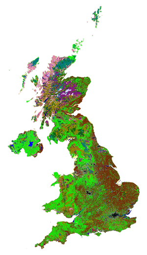
 These are one of a series of land cover maps, produced by UKCEH since 1990. They include versions in 1990, 2000, 2007, 2015, 2017, 2018 and 2019.
This collection contains these resources
publishedDataset
Land Cover Map 2000 (1km dominant aggregate class, GB)
publishedDataset
Land Cover Map 2000 (1km dominant aggregate class, N.Ireland)
publishedDataset
Land Cover Map 2000 (1km dominant target class, GB)
publishedDataset
Land Cover Map 2000 (1km dominant target class, N.Ireland)
publishedDataset
Land Cover Map 2000 (1km percentage aggregate class, GB)
publishedDataset
Land Cover Map 2000 (1km percentage aggregate class, N. Ireland)
publishedDataset
Land Cover Map 2000 (1km percentage target class, GB)
publishedDataset
Land Cover Map 2000 (1km percentage target class, N.Ireland)
publishedDataset
Land Cover Map 2000 (25m raster, GB)
publishedDataset
Land Cover Map 2000 (25m raster, N. Ireland)
publishedDataset
Land Cover Map 2000 (vector, GB)
publishedDataset
Land Cover Map 2000 (vector, N.Ireland)