
Land Cover Maps
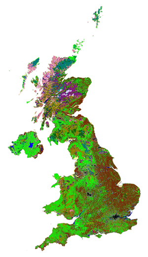 Land cover maps describe the physical material on the surface of the country. For example grassland, woodland, rivers & lakes or man-made structures such as roads and buildings
 UKCEH Land Cover Maps are parcel-based thematic classifications of satellite image data covering the United Kingdom. They are used in a wide range of applications by government departments & agencies, county councils, charities and environmental management bodies. The versions available are:
- Land cover map 1990 (original map GB only, the revised map gives full UK coverage)
- Land cover map 2000
- Land Cover Map 2007
- Land Cover Map 2015
- Land Cover Map 2017
- Land Cover Map 2018
- Land Cover Map 2019
- Land Cover Map 2020
- Land Cover Map 2021
- Land Cover Map 2022
- Land Cover Map 2023
- Land Cover Map 2024
Each version is available in several different products which vary in their level of detail and spatial resolution.
The most recent Land Cover Maps release is Land Cover Map 2024 (LCM2024).
In 2019, LCM 1990 was revised to cover the whole of the UK (it previously covered only Great Britain) and to support comparisons with LCM 2015 and the newer products. Using the revised LCM 1990, quarter-century change datasets have been created by comparison with LCM 2015 - these are also available.
NOTE: These UKCEH products relate to Land COVER, not Land USE. Land cover describes the physical material on the surface, whereas Land Use describes how the material is used. For example, land covered by grass could be used for grazing or sporting activities, or both. Land Cover is directly detectable from satellites, Land Use is not.
This collection contains these resources
publishedData collection
Land Cover Map 2023
publishedData collection
Land Cover Map 2022
publishedData collection
Land Cover Map 2021
publishedData collection
Land Cover Map 2020
publishedData collection
Land Cover Map 2019
publishedData collection
Land Cover Map 2018
publishedData collection
Land Cover Map 2017
publishedData collection
Land Cover Change 1990-2015
publishedData collection
Land Cover Map 2015
publishedData collection
Land Cover Map 1990
publishedData collection
Land Cover Map 2007
publishedData collection
Land Cover Map 2000
publishedData collection
Land Cover Map 2024